|
Mineral Lands Help File |
CONTENTS
IntroductionDescription of Layers
Map Staked Claims
Table 1 Fields in the Map Staked Claims database
Original Boundaries
Historical Claims
Table 2 Fields in the Historical Claims database
Mineral Rights Cancelled
Table 3 Fields in the Mineral Rights Cancelled database
Notices Gazetted
Table 4 Fields in the Notices Gazetted database
Mineral Tenure
Table 5a Fields in the Mineral Tenure database
Table 5b Mineral Tenure database Type codes and Type Descriptions
Figure 1 Legend for Mineral Tenure features
Recommended Citation
Contact
INTRODUCTION
The Mineral Lands Layers - in particular, the Map Staked Claims, Historical Claims, Mineral Rights Cancelled, Notices Gazetted and the Original Boundaries data sets - were developed by the Mineral Lands Division using the Province's Oracle based Mineral Rights Administration System - MIRIAD. Launched in February 2005, MIRIAD provided online map-based claim staking and updates, integrating mineral title information with the Province's geographic information system and financial management system. In April 2020, the updated Mineral Lands Administration Portal (MinLAP) came on line to provide clients with the ability to manage the claim staking, financial and reporting procedures themselves.
The Historical Claims data set includes ground and map-staked claims, impost lands such as fee simple mining grants and concession lands. It was developed by the Mineral Lands Division over several years by manually digitizating older claims maps. With the introduction of MIRIAD, and now MinLAP, any Map Staked Claims which have reverted to the crown are automatically archived and incorporated into the Historical Claims data set.
The Mineral Tenure data set includes data from the Mineral Lands Division (exempt mineral lands, impost lands and mining leases) as well as other provincial and federal government departments (i.e., ecological reserves, national historic sites, national parks, private parks, provincial parks, wilderness reserves, federal lands, provincial lands, specified materials, Labrador Inuit Lands, and lands of Quebec and France). Many of these features are also on the Land Use Atlas (https://www.gov.nl.ca/landuseatlas/details/).
The purpose of the development of the Map Staked Claims,
Mineral Rights Cancelled, Notices Gazetted, and the Original Boundaries data
sets is to provide the mining industry with real time claims information 24
hours a day, 7 days a week. These data sets, as well as the Mineral Tenure data
set, provide the mining industry with maps of those lands which are available
for claim staking and mineral exploration verses those areas which have been
alienated from the claim staking and mineral exploration process.
The purpose of
the development of the Historical Claims data set is to provide the mining
industry the ability to research past claim staking and mineral exploration work
on-line and to provide direct access to the digital mineral exploration work
reports (assessment reports as pdf files), through the Geofiles link, that have been filed with the Publications Section, Geological Survey
Division and the Mineral Lands Division.
Map Staked Claims:
These claims have been
staked via the Internet using MIRIAD and now MinLAP (Mineral Lands Administration Portal,
as of April 2020). The Map Staked Claims layer is updated in real
time. Each claim measures 500 m x 500 m (25 hectares or about 61 acres) and
is
based on the predetermined Universal Transverse Mercator grid using the 1927
North American Datum (NAD27).
The black polygon boundaries on the Map Staked
Claims layer are actually licence areas. These consist of a minimum of one
claim to a maximum of 256 contiguous claims. Licence areas may not
overlap existing claims or areas that are exempt from staking. Each licence is
assigned a unique number. The attribute database (i.e., tabular data)
associated with the Map Staked
Claims layer consists of one row of data for each licence. Table 1
provides a brief description of the fields available in the attribute database.
This data is updated in real time.
Table 1: Fields in the Map Staked Claims database.
|
Field |
Description |
|
License_NBR |
Mineral license number (with link to mineral rights data for that license including work report file numbers) |
|
FileNum |
Main registry file number assigned to each license |
|
Client_Name |
Official holder of a license |
|
Location |
General geographic location |
|
NumClaims |
Total number of claims in the license |
|
Status |
Issued – indicates that the map staked claim(s) are in good standing |
|
Stakedate |
Date when the Map Staked Claims were staked |
|
RecDate |
Date when the Map Staked Claims were recorded |
|
IssDate |
Date when the Map Staked Claims were issued |
|
RptDue |
Date when next assessment report is due |
|
Mapsheets |
Lists the Canadian National Topographic System of Maps that overlap the claims |
|
Total_Exp |
Total expenditures spent on the licence block |
Original Boundaries:
Original boundaries refer to claim boundaries
which have been established on the ground using ground staking or surveying
methods. For the most part these Original Boundaries represent ground staked
claim boundaries but also include boundaries of fee simple mining grants and
concession lands. Section
25.2 of the Mineral Act provides details. This data is updated in real time.
Historical Claims:
Historical claims represent all
ground and map staked claims, fee simple mining grants and concession lands that
have been cancelled, surrendered, partially surrendered, expired or forfeited.
Table 2 provides a brief description of the
fields available in the database.
This database is updated every evening.
Table 2. Fields in the Historical Claims database.
|
Field |
Description |
|
License_NBR |
Mineral license number (with link to mineral rights data for that license including work report file numbers) |
|
Filenum |
Main registry file number assigned to each license |
|
Client_Name |
Official holder of a license |
|
Location |
General geographic location |
|
NumClaims |
Total number of claims in the license |
|
Status |
Indicates if the map staked claim was cancelled (CA), surrendered (SU), partially surrendered (PS), expired (EX), grouped (GR) or deleted (DL) |
|
Stakedate |
Date when the Map Staked Claims were staked |
|
RecDate |
Date when the Map Staked Claims were recorded |
|
IssDate |
Date when the Map Staked Claims were issued |
|
RptDue |
Date when last report was due if license wasn't cancelled |
|
Mapsheets |
Lists the Canadian National Topographic System of maps that overlap the claim |
|
Total_EXP |
Total expenditures spent on the licence block |
Mineral Rights Cancelled:
Mineral rights (map staked claims, mining leases, fee simple mining grants and
concession lands) which have reverted back to the Crown for non compliance with
the Mineral Act and its associated Mineral Regulations and/or the Mineral
Holdings Impost Act and its associated Mineral Holdings Impost Regulations. This
includes cancelled, surrendered, partially surrendered and expired map staked
claims and surrendered, partially surrendered, expired or forfeited (non payment
of impost taxes) fee simple mining grants and concession lands. Table 3 provides a brief description
of the fields available in the attribute database. This data is updated in real time.
Table 3: Fields in the Mineral Rights Cancelled database.
|
Field |
Description |
|
Status |
Excluded lands - mineral rights that reverted back to the Crown but a notice has not been published yet in the Newfoundland and Labrador Gazette |
|
StartDate |
Null |
|
EndDate |
Null |
|
License_NBR |
Mineral license number (with link to mineral rights data for that license including work report file numbers) |
|
FileNum |
Main registry file number assigned to each license |
|
Client_Name |
Official holder of a license |
|
Location |
General geographic location |
|
NumClaims |
Total number of claims in the license |
|
StakeDate |
Date when the Map Staked Claims were staked |
|
RecDate |
Date when the Map Staked Claims were recorded |
|
IssDate |
Date when the Map Staked Claims were issued |
|
RptDue |
Date when the last assessment report was due |
|
MapSheets |
Lists the Canadian National Topographic System of maps that overlap the claims |
|
Total_EXP |
Total expenditures spend on the licence block |
Notices Gazetted:
Mineral rights which have been cancelled, surrendered, partially surrendered,
expired or forfeited that have had a notice published in the
Newfoundland and Labrador
Gazette as per
Section 62 of the Mineral Regulations. Notices are published on Fridays and
the mineral rights will become available for claim staking, through normal
on-line claim staking procedures, at 9:00 in the morning of the thirty-second
day after publication (always a Tuesday). Table 4 provides a brief description
of the fields available in the attribute database. This data is updated in real time.
Table 4: Fields in the Notices Gazetted database.
|
Field |
Description |
|
Status |
Mineral rights notice has been "Gazetted" or "Excluded"in the Newfoundland and Labrador Gazette |
|
StartDate |
Null |
|
EndDate |
Time and date when the mineral rights will come open for on-line map staking |
|
License_NBR |
Old mineral license number (with link to mineral rights data for that license including work report file numbers) |
|
FileNum |
Old main registry file number assigned to each license |
|
Client_Name |
Official holder of the old license |
|
Location |
General geographic location |
|
NumClaims |
Total number of claims in the license |
|
StakeDate |
Date when the Map Staked Claims were staked |
|
RecDate |
Date when the Map Staked Claims were recorded |
|
IssDate |
Date when the Map Staked Claims were issued |
|
RptDue |
Date when the last assessment report was due |
|
MapSheets |
Refers to the Canadian National Topographic System of maps |
|
Total_EXP |
Total expenditures |
Mineral Tenure:
The Mineral
Tenure data set includes mining leases (issued under the Mineral Act and also
through private legislation) and impost lands (fee simple mining grants and
concession lands). In addition, the data set includes ecological reserves,
exempt mineral lands, national historic sites, national parks, private parks,
provincial parks, wilderness reserves, and lands of
Table 5a. Fields in the Mineral Tenure database.
|
Field |
Description |
|
TypeCode |
Numeric code for each feature type (see Table 5b) |
|
Comments |
Comments such as 'current holder' |
|
TypeDesc |
Mineral Tenure type (e.g., ecological reserves, federal lands; see Table 5b) |
|
Feature name |
Official name assigned to the feature (e.g., Avalon Wilderness Reserve) |
|
Company number |
Official client number assigned by the MIRIAD or MinLAP on-line staking registration procedures to the holders of fee simple mining grants, mining leases and concession lands |
|
Company name |
Official title holder of fee simple mining grants, mining leases and concession lands |
|
NTSMap |
Refers to the Canadian National Topographic System of maps |
Table 5b. Mineral Tenure database Type Codes and Type Descriptions.
|
MINERAL TENURE | |
|
Type Code |
Type Description |
|
7 |
Ecological Reserve |
|
2 |
|
|
12 |
|
|
21 |
|
|
4 |
|
|
18 |
LIL |
|
1 |
Mining Lease |
|
10 |
National Historic Park |
|
9 |
National Park |
|
15 |
|
|
6 |
|
|
8 |
Wilderness Reserve |
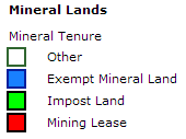
Figure 1. Legend for Mineral Tenure areas.
Digital data issued by the Mineral Lands Division of the
Mining and Mineral Development Branch, Newfoundland and Labrador
Government, are made available for public use. The user
agrees not to provide a digital reproduction or copy of this product to a third
party. Derivative products should acknowledge the source of the data.
Mineral Lands, a division of the
RECOMMENDED CITATION
(for downloaded database: example is provided for Map
Staked Claims)
The 'Last Update' refers to the last time the database
information was updated. Most of the Mineral Lands layers are updated in real
time (see notes above).
To top
CONTACT
Mineral Lands Division
Mining and Mineral Lands Branch
Government of Newfoundland and Labrador
P.O. Box 8700
St. John's, NL A1B 4J6
Mineral Lands Administration (Claim Staking) Email: MinLapadmin@gov.nl.ca
Quarries Email: Quarries@gov.nl.ca
(Help file last updated: April 2022)
To top